BRAZIL - DAY 1 OF 6 · ~29 MIN
Before Brazil
Lisbon, 1502. A man working for the Duke of Ferrara is buying a map he is not supposed to have.
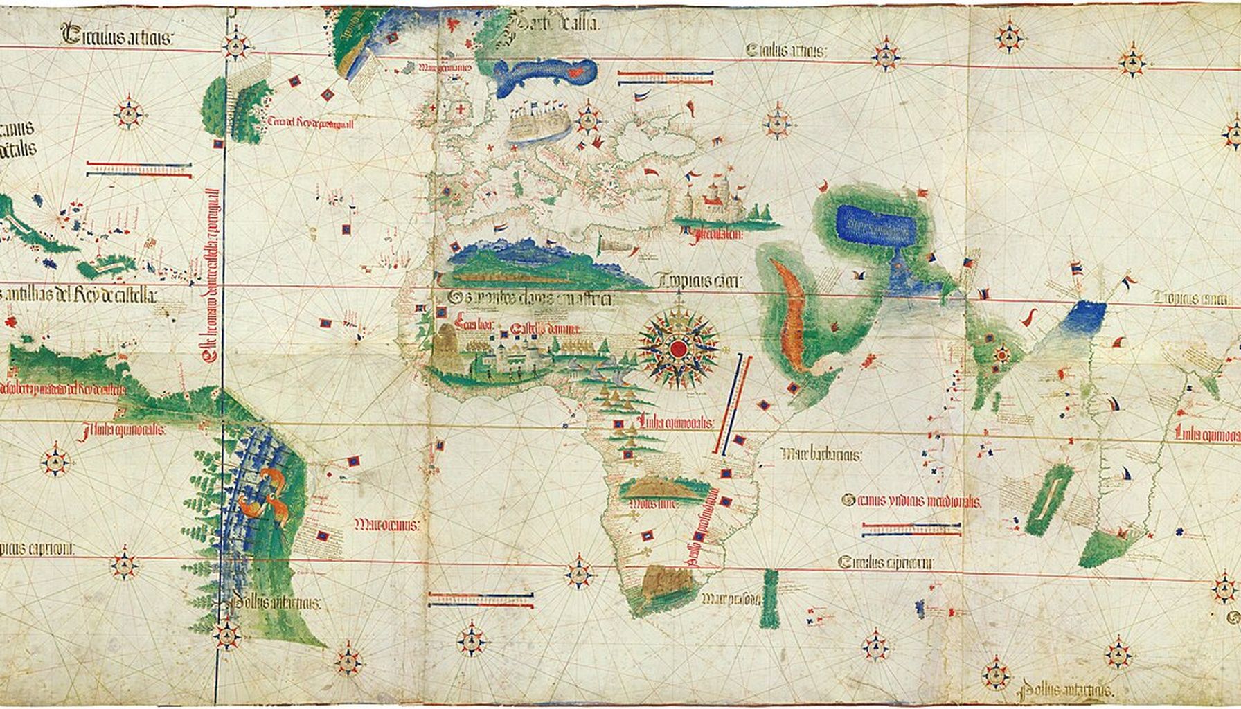
A section of the Cantino planisphere, drawn in Lisbon in 1502 by a mapmaker whose name is lost. It is the earliest surviving chart to show the Brazilian coast, which appears here at the lower left, drawn with trees and two macaws on it. The straight vertical line running down the ocean is the meridian agreed at Tordesillas in 1494. Portugal and Spain had used it to divide the unexplored world between them: everything east of the line was Portugal's, everything west was Spain's. Nobody could measure longitude at sea in 1502, so where that line actually fell on the ground was argued about for the next two hundred and fifty years. Anonymous Portuguese chart, 1502 / Wikimedia Commons / Public domain
Contents — 8 sections
BEFORE YOU READ
Estimates of how many people were living in Brazil in 1500 are disputed by millions. What is the spread between the lowest and the highest serious figure?
OPENING SCENE

Lisbon, 1502. A man working for the Duke of Ferrara is buying a map he is not supposed to have.
His name is Alberto Cantino. Ercole d'Este, Duke of Ferrara, has sent him to Portugal, and part of his job is to find out what Portuguese ships have been finding. Portugal treats its sea charts as state secrets.
Cantino locates a mapmaker willing to copy the crown's master chart. His own letter records the price: twelve gold ducats. The finished map reaches Ferrara in November 1502.
It is a large object, about two metres of joined parchment. Much of it is the world Europe already knew. At the lower left is a coast that no European had seen three years earlier.
The mapmaker has drawn that coast as a green fringe with trees along it and two macaws standing on it. A straight vertical line runs down the ocean nearby. That line is a border between two empires, agreed in 1494 by two states that had no way of measuring where it went.

Behind the fringe of trees, the parchment is blank. Lisbon knew a shoreline, some parrots and a claim, so a shoreline, some parrots and a claim is what got drawn.
The land behind that blank was not blank. It held towns, mounds, painted burial urns and farmland that people had manufactured out of charcoal and rubbish. It held somewhere between under a million people and well over four million, depending on whose estimate is used.
Portugal named that land after a cargo. The name it chose is the one still on the map today.
Today's Core Question: If a country takes its name from a cargo, what was here before the cargo?
DID YOU KNOW?
Luzia burned. On 2 September 2018 a fire destroyed most of the National Museum in Rio de Janeiro, which held her and about twenty million other items. Her skull was in the debris and was recovered in pieces. Around eighty per cent of the fragments were found. The shell mounds were quarried for building material. Sambaquis are made largely of shell, shell burns down to lime, and lime makes mortar. Many of the mounds on the southern coast were burned for exactly that. Structures that people had spent four or five thousand years building went into the walls of colonial churches that are now themselves protected as heritage. The first surviving document about Brazil ends with a favour. Pero Vaz de Caminha spends fourteen pages on the land, the people, the Masses and the cross. Then he asks King Manuel to bring his son-in-law Jorge de Osouro home from the island of São Tomé, where he had been sent into exile. Greenlee's note explains the case. Osouro had been dragged out of a church where he had taken sanctuary, accused of stealing bread, wine and chickens and of wounding a priest.
THE FIRST PEOPLE, AND WHAT SURVIVES OF THEM

People reached the far southern end of South America a very long time before anyone reached it by sea from Europe. The site that settles that is not in Brazil. It is in southern Chile.
Monte Verde sits near the Chilean coast, roughly six hundred kilometres south of Santiago. Tom Dillehay excavated it from the late 1970s. Wooden stakes, hearths, plant remains and a preserved footprint were dated to about 14,500 years ago.
In years BCE that is roughly 12,550. The date usually given is about 12,500 BCE.
What makes the date matter is the location. Monte Verde is near the bottom of the continent. For people to be living there, they had already come the whole length of South America from the north.
Fourteen and a half thousand years is hard to hold in the head. The oldest writing known anywhere is about five thousand years old. People had been living at the southern end of this continent for nine thousand years before anybody, anywhere, wrote anything down.
The date also broke a model. For decades the standard account had the first Americans arriving about 13,000 years ago and spreading south from there. Monte Verde is older than that and sits at the far end of the route, so the model had to change.
Brazil's own oldest firmly dated sites come a little after Monte Verde. One place in Brazil claims dates far older, and that claim is disputed.
The place is Serra da Capivara, in the state of Piauí in the dry north-east. The French-Brazilian archaeologist Niède Guidon has argued from the shelter of Pedra Furada that people were there 30,000 years ago and more.
Her critics say the burnt stones and broken flakes she reads as human work could have been produced without any people involved. Quartzite cobbles fall from the cliff above and fracture. Fires start on their own.

David Meltzer, James Adovasio and Tom Dillehay visited the site in 1993 and published that objection. Guidon has not accepted it, and the disagreement is still live.
(The dispute is only about the oldest layers. Nobody disputes that Serra da Capivara was lived in for many thousands of years, or that the paintings there are real.)
The paintings are the reason most people know the place. Hundreds of rock shelters in what is now Serra da Capivara National Park carry painted figures: hunts, dances, animals, rows of people holding hands. The painting is usually dated from around 10,000 BCE.
What is striking about them is how ordinary the subjects are. They show hunting parties, deer and other animals, dancing, sex and childbirth. This is a record of daily life, painted by people who left no other record of any kind.
The scale is the thing to take from it. The park holds more than a thousand recorded archaeological sites, and over nine hundred of them have paintings. UNESCO listed it in 1991.
The other survival a reader can picture is a skull.
The caves around Lagoa Santa in Minas Gerais have been producing human bones since the 1830s. The Danish naturalist Peter Lund dug there and found them mixed in with the bones of extinct animals. In 1975 a team led by the French archaeologist Annette Laming-Emperaire was working a cave called Lapa Vermelha. They found the remains of a young woman, later given the name Luzia.
She is among the oldest human remains found anywhere in the Americas. Her age is usually given as about 11,500 years, and that figure needs one line of explanation. Archaeologists count those years back from 1950 rather than from now, so 11,500 years ago works out at about 9500 BCE.
Luzia is a person rather than a proof, and one skeleton settles nothing on its own. But she and the painted shelters are most of what physically survives from the first ten thousand years of human life in Brazil. Some bones, some paint on rock, and an argument about dates that is not finished.
Monte Verde, the site that fixes when people reached the far south of this continent, is in Chile and not in Brazil. Why does a Chilean site settle the question?
FARMERS, FISHERS AND THE FIRST POTTERS

Three things were invented here, in three different parts of the country, and not one of them was borrowed from anywhere else.
The first is a plant. Manioc, also called cassava, is a shrub with a thick starchy root. It was bred out of a wild relative in what is now Rondônia and Acre, in the south-west Amazon, about ten thousand years ago.
That date was not dug out of the ground. Roots rot, so there is very little to excavate. It comes from comparing the DNA of the crop with the DNA of its wild relative and working out how long the two have been apart.
Manioc grows in thin, sour soil where maize fails. That is why it spread. It became the staple food of most of lowland South America and it still is, and it is now grown across Africa and Asia as well.
Turning it into food takes work. The highest-yielding varieties carry cyanide compounds and are poisonous raw. They have to be grated, pressed to squeeze the liquid out, and then cooked. The processing is as much an invention as the plant.
The second thing is on the coast, and it is enormous. From about 6000 BCE, peoples along the southern shore piled up shell, fish bone, ash, charcoal and their own dead into mounds. The Tupi word for one of these mounds is sambaqui, which means a heap of shells.
They are not rubbish tips. The mounds hold burials, hearths and house floors, laid down in layers over centuries, and archaeologists now read many of them as monuments that were built on purpose. The people who built them lived mainly on fish and shellfish, and their mounds were visible from a long way out to sea.

About a thousand of them survive, most in Santa Catarina and Paraná, with others scattered north as far as the Bahia coast. The largest, Garopaba do Sul in Santa Catarina, stood more than thirty metres high before quarrying took most of it away. Thirty metres is a ten-storey building, made of shells.
The building went on for a very long time. At some sites the layers run from around 6000 BCE to well into the first millennium CE. That is four or five thousand years of people adding to the same mound.
The third thing is pottery, and it is on the Amazon. At Taperinha, close to where Santarém stands today, Anna Roosevelt dated pots to about 7,000 years ago. The clay had crushed shell mixed through it, which stops a pot cracking when it is fired.
The careful way to state what that means is this. It is older than any pottery known from Mexico or from the Andes. It is not safely the oldest in the Americas, because sites in Colombia are argued to be older still.
Pottery is worth the fuss because of what it lets people do. Food can be boiled in it, stored in it and carried in it. A people who fire pots are usually a people who have stopped moving so much.
So by about 5000 BCE there was a bred crop in the south-west, monumental mounds along the southern coast, and fired pottery on the lower Amazon. Three achievements, three regions, and no outside source for any of them.
Manioc was bred out of a wild shrub in the south-west Amazon about ten thousand years ago. How is that date known, when almost nothing of the plant survives in the ground?
THE AMAZON MAKES ITS OWN SOIL AND BUILDS TOWNS

Rainforest looks like the richest ground on earth and is not. Almost all the nutrients in an Amazon forest are held inside the trees, not in the soil beneath them. Clear a patch and it will feed a family for a season or two, and then it stops.
That is why the Amazon was long assumed to have held almost nobody before 1500. Land that cannot grow a surplus cannot hold a crowd.
The assumption was wrong, and the evidence for that is in the dirt.
Scattered through the Amazon are patches of very dark, very fertile earth. They are full of charcoal, broken pottery, fish bone, animal bone and household waste, built up over generations. Portuguese speakers call this soil terra preta, black earth.
None of it is natural. It is the residue of people staying in one spot for a long time, burning fuel and throwing things out. The charcoal is the reason it lasts, because charcoal holds nutrients in place instead of letting the rain wash them away.
Some of the patches run to several square kilometres. That makes terra preta a map of settlement. Where the black earth is, there was a community large enough and settled enough to make soil by accident and then farm it on purpose. The oldest patches date from around 500 BCE.
How much of the Amazon is black earth is not settled. Published estimates run from a fraction of one per cent of the basin up to something like ten per cent. A range that wide is itself the finding, because it means most of the forest floor has never been surveyed for it.
The settlements themselves show up at the mouth of the river. Marajó is an island in the Amazon delta about the size of Switzerland, and a large part of it floods every year.
From about 400 CE the people usually called the Marajoara raised earth mounds there, above the flood line, and lived on top of them. Some of the mounds stand several metres high and cover hectares of ground. The Marajoara went on building for roughly a thousand years.

Their pottery is unmistakable. The burial urns reach a metre tall and are painted and incised in red, black and white.
The mounds held house floors as well as graves. The dead stayed inside the settlement rather than outside it.
How many Marajoara there were is a genuine argument, and it is worth having in full.
Betty Meggers held that Amazon soils could never support a complex society, and that anything complex found there must have arrived from the Andes and then decayed. Her book of 1971 called the region a "counterfeit paradise". On that reading, Marajó held a few thousand people.
Anna Roosevelt excavated on Marajó herself and reached the opposite conclusion. She argued that the culture developed locally, lasted a thousand years, and at its height supported something like a hundred thousand people.
The gap between those two answers is not a rounding error. It is the difference between a scatter of villages and the population of a mid-sized modern city, on one island.
Upriver, at the mouth of the Tapajós, there was a town. The Tapajó people built it where Santarém stands today, and they made a pottery style that is recognisable at a glance, crowded with modelled animals and human figures.
The black earth under and around the modern city runs for several square kilometres, which is what a large and long-lived settlement leaves behind. Europeans who travelled the length of the Amazon in the 1540s described riverbanks settled almost without a break. Archaeologists still argue about how many people that means.
What is no longer argued is the shape of the thing. The Amazon before 1500 was not empty forest with a few people in it. It was farmed and settled, and in the places settled hardest the people had made the farmland themselves.
Terra preta, the black earth scattered through the Amazon, is charcoal, broken pottery, fish bone and household waste built up over generations. What does a patch of it tell an archaeologist?
"They agree to carry enough brazil-wood and slaves." Piero Rondinelli, Florentine merchant, on the terms of the first Brazilian trade monopoly, Seville, 3 October 1502, in W. B. Greenlee's translation
THE PEOPLES THE SHIPS WOULD MEET

By 1500 the land had been lived in for something like fourteen thousand years. Saying who was living in it means starting with language, because language is how the peoples of Brazil are still grouped.
A language family is a set of languages descended from one older language. Portuguese, Spanish, French, Italian and Romanian are a family, because all of them come out of Latin. Brazil in 1500 had several such families, and three of them matter most.
The first held the coast. Over centuries, peoples speaking closely related Tupi languages moved out of the interior and took most of the seaboard. The Tupinambá, the Tupiniquim, the Tamoio, the Caeté and the Potiguara are among the names the Portuguese recorded.
The spread is startling when it is measured. Alfred Métraux described the coastal Tupi as sharing one language and one material culture from the mouth of the Amazon to Rio Grande do Sul. That is roughly four thousand kilometres of coast, which is further than Lisbon is from Moscow.
A stretch that long with that little variation points one way. The Tupi expansion along the coast was recent, and it was still recent when the ships arrived.
Tupi villages were built around an open central square, with a few very large communal houses standing round it. Several families lived in each house.
Gardens of manioc and maize were cut and burned out of the forest nearby. When the soil thinned and the game moved off, the whole village moved with it and started again a few kilometres away. A settlement was a decade or two in one place, not a permanent town.
Felling trees was collective men's work, done with fire and stone axes. That detail matters for what happened after 1500, because it meant the coast already had an organised way of cutting timber.
Coastal peoples also made war on each other, and the object of the fighting was captives rather than land. A captive taken in war was held and then ritually killed. Portuguese and French traders would later buy such captives instead, which is how a European market attached itself to something that already existed. What Portugal then did with that in law is Day 2's.
The second family held the country behind the coast. The Kaingang, the Xavante, the Xerente, the Kayapó and the Timbira speak Jê languages, and they lived on the highlands and the dry interior plateaus.
Their village plan is different and deliberate. Many Jê peoples built their houses in a ring around a cleared central plaza. The position of a house in the ring marked out which group inside the community lived there, so the village plan was also a diagram of the society. The plaza was where ceremony and public argument happened.
Further south, Jê-speaking peoples on the highlands of Santa Catarina and Paraná dug their houses into the ground and roofed them over. Hundreds of these pit dwellings survive as circular hollows in the earth. Those uplands are cold in winter by Brazilian standards, and a house below ground level holds its heat.

The third family is the Guarani, close relatives of the Tupi, who held the river valleys of the south and the far south-west. Tupi and Guarani are close enough that speakers of the two could make themselves understood to each other. Guarani descendants are still on those rivers, and Day 3 meets them again on a border.
The Portuguese had a single word for everyone inland who was not Tupi. They called them "Tapuia". It is a Tupi word meaning outsiders or barbarians, borrowed from the coastal peoples who used it about their enemies. It was never the name of a nation, and it covered dozens of peoples speaking unrelated languages.
That leaves the largest question, and the five days after this one keep coming back to it. How many people were here.
The honest answer is that nobody knows, and the estimates are disputed by millions. They are also produced by methods that do not measure the same thing, which is why an average of them would be meaningless.
Alfred Kroeber, in 1939, put the figure at well under a million. Ángel Rosenblat, in 1945, gave about 1.4 million for Brazil. Julian Steward, in 1949, gave about 1.5 million.
William Denevan, in 1970 and revised in 1977, reached 4,834,000 for the Amazon basin inside modern Brazil. He then cut his own figure to 3,625,000, to allow for empty buffer zones between peoples who were at war. Pierre Clastres, in 1973, argued for figures higher again.
John Hemming's own estimate, published in 1978, is 2,431,000. He built it by estimating each people and adding them up, and in his appendix he describes it as "pure guess-work".
Three different methods are at work in that list. One multiplies an assumed population density by an area. One counts peoples one at a time and adds them up. One extrapolates from what eyewitnesses claimed to have seen.
They disagree because they are asking the question differently, not because two of them are careless. Averaging them would produce a number that nobody holds and no method supports.
There is a deeper problem underneath all of them. Almost everything written down about Brazil in the sixteenth century was written on the coast, by people who had come by ship and stayed near it. The interior is most of the country and it is the part with the least evidence, so the estimates are weakest exactly where the land is biggest.
One comparison gives the numbers a size. Portugal itself held somewhere around a million people in 1500. Even the lowest estimate here is in the same range as the whole country that was about to claim the place. The higher ones are several times larger.
So this is who the ships met. At least three large language families, and dozens of named peoples with their own territories and their own quarrels. Farming villages that picked up and moved every ten or twenty years. And a total population that cannot be counted, only argued about.
Estimates of how many people were living in Brazil in 1500 are disputed by millions. What is the spread between the lowest and the highest serious figure?
A LINE ON A MAP, THEN NINE DAYS ASHORE

In 1493 Christopher Columbus came back to Europe and reported land in the west. What happened next was a paperwork race between two kingdoms.
Spain went to the Pope. Alexander VI issued bulls granting Spain everything beyond a line drawn one hundred leagues west of the Azores and Cape Verde islands. Portugal objected, because that line cut across the Atlantic routes its own ships were using.
So the two states negotiated directly and settled it themselves. On 7 June 1494, at Tordesillas in Castile, they agreed a meridian 370 leagues west of the Cape Verde islands. Everything east of it would be Portugal's and everything west of it Spain's.
Three hundred and seventy leagues is roughly two thousand kilometres. The difficulty is that nobody in 1494 could measure two thousand kilometres of open ocean, because longitude at sea could not be fixed. The two crowns argued about where the line really ran for the next two hundred and fifty years.
What neither of them knew was that the line crossed South America. That single fact is why Brazil speaks Portuguese and the rest of the continent does not.
Six years later a Portuguese fleet came over the horizon.
Pedro Álvares Cabral's thirteen ships gathered in the Tagus on 8 March 1500 and sailed the next day, carrying about 1,200 men. They were bound for Calicut, on the coast of India. Portugal had reached India by sea two years earlier and meant to make it a trade route.
On Wednesday 22 April 1500 they sighted a high round mountain. Cabral named it Monte Pascoal, for Easter, which had fallen on 19 April that year. He named the land Terra da Vera Cruz, land of the True Cross.
The fleet stayed nine days. Nicolau Coelho took a boat ashore and met eighteen or twenty men on the beach, and traded a red cap and a linen cap for a feather headdress.
On Sunday 26 April a Mass was said on an island offshore by Frei Henrique, with a tent and an altar set up on the sand. On 1 May a cross was planted with the royal arms nailed to it, and a second Mass was said at its foot. The fleet's clerk recorded "some fifty or sixty natives, all kneeling as we were".
On 2 May they left for India. The rest of that voyage went badly. Bartolomeu Dias was sailing with Cabral, and he had been the first European to round the Cape of Good Hope twelve years earlier. He drowned off southern Africa a few weeks after leaving this coast.
Four men stayed behind, and two of them were left on purpose. Cabral put it to his captains whether to seize two local men and carry them home. The captains advised against it, on the grounds that people taken by force say whatever they think is wanted.
So two convicts were put ashore instead. The Portuguese word is degredado, a man sentenced to exile rather than to prison. Two crewmen then deserted on the last night and stayed as well. Portugal used exile as a survey instrument, and it kept doing so.
One ship was sent home under Gaspar de Lemos with the news, and, according to Hemming, with some logs of dyewood aboard.
Nine days is the whole of it. Cabral did not found anything, garrison anything or claim any ground beyond planting a cross. He took on water, held the Easter services he had missed at sea, filed a report and sailed on.
That is also why the word for 1500 is not discovery. Somewhere between one and four million people were already living here. The fleet reached a coast; it did not find an empty one.

Whether it reached that coast by accident is argued. W. B. Greenlee and John Hemming both treat the sighting as chance, and the route Cabral was sailing swings wide into the Atlantic for the winds. Other historians hold that the crown already suspected land lay out there when it negotiated Tordesillas in 1494 and pushed the line west for exactly that reason.
What is not argued is what the clerk wrote home.
Pero Vaz de Caminha's letter to King Manuel I is dated 1 May 1500 and runs to fourteen folio pages. It is the first Portuguese assessment of the place, and it reads like a survey of a business proposition.
In Greenlee's translation: "Up to now we are unable to learn that there is gold or silver in it, or anything of metal or iron; nor have we seen any, but the land itself has a very good climate… Its waters are quite endless."
No metal. That one finding is why no settlers followed for thirty years.
Caminha then made a recommendation. "So pleasing is it that if one cares to profit by it, everything will grow in it because of its waters. But the best profit which can be derived from it, it seems to me, will be to save this people, and this should be the chief seed which Your Highness should sow there."
He added a second-best case, and it is the one the crown acted on first. "And if there were nothing more than to have here a stopping-place for this voyage to Calicut, that would suffice…"
Then he signed off. "From this Porto Seguro of your island of Vera Cruz to-day, Friday, the first day of May of 1500. Pero Vaaz de Caminha."
He thought it was an island. Nobody had been far enough along the coast to know otherwise.
The name in that sign-off did not last. The argument over what to call the place ran for thirty years, and it ended somewhere nobody writing in 1500 would have picked.
Cabral had called the land Vera Cruz, the True Cross. Churchmen preferred Santa Cruz, Holy Cross. Sailors, in Venetian letters written in June 1501, called it the land of parrots, though the surviving letters disagree about which writer used the phrase and when.
All three lost to a fourth name, and that fourth name was already in use in Europe before any European saw South America. Brasil was medieval shorthand for a red dyewood imported from Asia.
There was even a phantom island of that name. An "Isle of Brazil" was drawn on the Medici atlas of 1351, a century and a half early. It wandered around the Atlantic on charts for another two hundred years and was never found, because it was never there.
By about 1530 the commodity name had beaten the religious ones. Greenlee, editing Caminha, records that the clergy "bitterly resented the substitution of the vulgar name of Brazil for that of Sancta Cruz."
They lost. The country took the name of the thing being shipped out of it.
Cabral named the land Vera Cruz and churchmen preferred Santa Cruz. By about 1530 both had lost to Brasil. Where did that name come from?
A SURVEY FLEET, AND THE FIRST CONTRACT

Caminha's letter told King Manuel that the new land had no metal in it. The crown's response was not to settle the place. It was to find out how long the coast was and what could be taken off it.
A fleet sailed in 1501 to do exactly that, and it mapped thousands of kilometres of shoreline over the next year. Its method of naming places was simple: whatever saint's day it was when they arrived, that became the name.
That is why so much of the Brazilian coast is a calendar. The Bay of All Saints was named on 1 November 1501, All Saints' Day, and Salvador stands on it now.
Tradition has the fleet entering a great bay on 1 January 1502 and calling it Rio de Janeiro, the January River. It is not a river. It is the entrance to a bay, and the crew appear to have misread it.
Almost everything else about that fleet is disputed. Tradition names Gonçalo Coelho as its commander. Some accounts put André Gonçalves in charge instead. Whether Amerigo Vespucci sailed with it at all is argued, and so is how much of the account written under his name he actually wrote.
Vespucci's letters travelled further than his ships did. In 1507 a German mapmaker, working from letters describing this coast, printed a world map that labelled the new continent America, after Vespucci's first name. Portugal had reached it seven years earlier.
The 1501 report itself was blunt. In Hemming's account of it, the land held nothing of use apart from a quantity of a certain tree.
The tree was pau-brasil, brazilwood. Its heartwood is cream-coloured where the axe goes in and turns deep red as the air reaches it. Rasped down to sawdust and steeped, it gives a strong red dye.
That is the entire reason the ships kept coming. Europe had no cheap, strong, reliable red for cloth, and red cloth was expensive. A wood that made one was worth crossing an ocean for.
The tree only grows in the Atlantic forest, in a belt running down the eastern side of the country. So the trade had a geography built into it from the start. Cutting happened wherever a ship could get close to shore, and it stayed close to shore for decades.
The king claimed the wood as his own property. Cutting it without a royal licence was illegal. That is why the trade took the shape it did: not a rush of independent merchants, but a monopoly leased out to one group at a time.
In 1502 a group of Lisbon merchants leased that whole trade from the crown. Fernão de Noronha was among them.
What they agreed to do is known from one letter. A Florentine merchant, Piero Rondinelli, wrote it from Seville on 3 October 1502.

The terms he sets out are specific. Six small ships a year. Three hundred leagues of new coastline explored annually. A fortress to be built, and three years' residence. Nothing paid to the crown in the first year, a sixth in the second and a quarter in the third.
And then the cargo. The holders, Rondinelli says, agree to carry enough brazil-wood and slaves.
The lease itself is dated only to the year. Rondinelli's letter is the only part of the arrangement with a day on it.
There was no colony on that coast in 1502. No governor, no capital, no plantation, no town. There was a contract, and people were already inside it.
Noronha did get land out of it, though not on the mainland. In 1504 the crown granted him the island group off the north-east coast that still carries his name, Fernando de Noronha. It was the first hereditary land grant Portugal made in Brazil. Carving up the mainland coast the same way came thirty years later, and that is Day 2's.
The next thing built was a shed. In 1503 or 1504, accounts differ, the Portuguese left a trading station at Cabo Frio, east of where Rio de Janeiro stands now. The Portuguese word is feitoria: a store, a stockade and a handful of men left behind to trade until the next ship came.
About two dozen men stayed. Their job was to cut and stack wood between visits so a ship would not have to wait.
They did not do the cutting. Tupi workers felled the trees, trimmed them and carried them to the shore, and they were paid in iron tools, knives, fish hooks, mirrors and cloth.
That exchange is why the trade worked at all. A steel axe did in a day what a stone axe did in a week.
Felling was already collective men's work on that coast. So the new trade slotted into an arrangement that was already running, and nobody had to be forced into it. For about thirty-five years the Portuguese got wood, manioc flour and labour by barter, and Stuart Schwartz dates that barter phase from 1500 to about 1535.
The 1502 contract's other clause sat alongside all of that. Buying captives was possible on the same coast, from the same partners, in the same years, and the letter from Seville says so on the face of it.
So four years after Caminha's letter, Portugal had a lease, a shed, a supply chain and a name for the place. It had no colony at all.
For about thirty-five years the Portuguese got dyewood off this coast by barter rather than by force. What made that arrangement work on the Tupi side?
A CARGO WITH PEOPLE IN IT

What that trade actually put in a ship's hold can be read off one document, because one ship's record survives.
The Bretoa left Lisbon in February 1511. She was a nau, a round-bellied merchant ship of the same class as Columbus's Santa Maria. Thirty-six men were aboard: five officers, thirteen able seamen, fourteen apprentices and four pages.
Her owners were the men who held the lease. Fernão de Noronha was one of them, nine years on from the contract Rondinelli described.
She spent a month in the Bay of All Saints, then worked south to the trading station at Cabo Frio and started loading. Three or four hundred logs went aboard every day.
Each log weighed about fifty pounds. She loaded about five thousand of them. That comes to roughly 125 tons, which was most of what a ship her size could carry.
The manifest survives in Portugal's royal archive, and the order of the list is the point.
Five thousand logs. Then parrots. Then animals. Then jaguar skins. Then thirty-five people.
The people are entered after the jaguar skins, on the same list, in the same hand, as part of the same cargo. There is no separate document for them and no separate heading. The manifest is reproduced in John Hemming's Red Gold.
The record gives a number and not a single name. Thirty-five people went aboard that ship, and nothing survives of who any of them was, where they came from or what happened to them. That is a fact about who was keeping the books.
The market they were being carried into already existed. Lisbon in 1511 had held enslaved Africans for half a century, bought on the West African coast by Portuguese ships. Nobody in the port would have had to explain what the last line of the manifest meant.
That is 1511. There is no colony on this coast, no capital, no governor, no sugar mill and no Portuguese town of any kind. There is an anchorage, a commodity and a clerk keeping a list.
The absence was a policy rather than an oversight. Portugal ran its whole eastern empire this way, from West Africa to India. A fort, a warehouse, a clerk and a licence, planted at the point where a cargo could be loaded. A trading post costs a fraction of a settlement, and it does not need farmers, families or soldiers to hold ground.
By then a few Europeans were living inside Tupi society rather than trading with it from a ship. Diogo Álvares, called Caramuru, was wrecked near the Bay of All Saints around 1510. He lived among the Tupinambá for decades and married into them.

João Ramalho did the same thing on the Piratininga plateau, inland from the southern coast. Both men learned the language, took in-laws and built standing with the peoples around them.
That made them the most valuable men on the coast to anyone arriving from Lisbon. Both were still alive, and still working as go-betweens, when the crown finally sent a government out. That is Day 2's arrival, and they are waiting on the beach for it.
Two things were coming after that, and both of them were already visible before 1530.
The first was written in Lisbon in 1516. King Manuel ordered a mill-builder shipped out to Brazil, with tools and technicians, and instructed his officials there to give him what he needed.
Portugal already knew this business well. It had been making sugar pay on Madeira since the middle of the previous century, and then on São Tomé, an island off the African coast, using enslaved African labour. That was sixty years of practice, and the crown intended to repeat the arrangement here.
What the mills became is Day 2's subject. The date on the order matters here: 1516 is fourteen years before anyone tried to settle the place.
The second thing was already on the water. French merchants from Rouen, Dieppe and Honfleur had worked out that the dyewood coast had nobody guarding it.
France had not signed the treaty of 1494 and did not regard itself as bound by it. Its ships traded iron for logs with Tupinambá partners, loaded cargoes and sailed home, and they did not ask Lisbon for permission. Some French crews stayed on the coast and lived among their trading partners, exactly as Caramuru and Ramalho had.
Portugal's answer, in 1526, was Cristóvão Jaques and a squadron of armed patrols sent to clear them off. The patrols took French ships. French ships kept arriving.
Patrols could not hold a coastline, because Portugal had no settlement anywhere on that coast capable of holding anything. A lease and a shed are not a border.
That is what finally changed Lisbon's mind. Rival ships were working the trade, and a coast with nobody living on it could be claimed by whoever did live on it. The cheap arrangement had run out, and the expensive one had to start.
That is the position in 1529. A name taken from a dye, a monopoly, a trading post at Cabo Frio, two castaways married into local families, an order for a mill-builder, and French ships working the same trees.
And behind all of it, the manifest. Logs, parrots, animals, jaguar skins, thirty-five people, in one hand, on one list.
Why it matters today
Brazil's Indigenous peoples are still here, and the country now counts them twice. The 2022 census recorded 1,694,836 Indigenous people in total, and 1,227,642 who gave indígena as their colour or race. The gap comes from an extra self-identification question asked on Indigenous lands.
They belong to 391 peoples and speak 295 languages. Every population estimate for pre-1500 Brazil is an attempt to say what that number used to be.
The languages are also in the map of the country. Guanabara, Ipanema, Itaipu, Paraná, Iguaçu and Piratininga are Tupi words, and so are several thousand other Brazilian place names. Rio de Janeiro's bay carries a Tupi name and a Portuguese one at the same time.
The black earth is still being farmed. Amazonian smallholders look for the terra preta patches and plant on them, because those patches hold fertility that the surrounding soil loses in a season or two. Soil made by people who died five hundred to two thousand years ago is still the best ground in the neighbourhood.
Serra da Capivara is a working national park, created in 1979 and listed by UNESCO in 1991. Its thousand-odd sites are still being surveyed. The oldest question in Brazilian archaeology is how long people have been here, and it is being argued out on ground that is open to visitors.
The tree itself is now protected. Brazilwood was cut hard for three centuries and is today a threatened species, surviving mostly in fragments of Atlantic forest and in planted stands. A federal law of 1978 made it Brazil's national tree.
The line drawn at Tordesillas in 1494 never fell where anyone could prove. Portugal and Spain went on disputing it, and settlers went on walking past it. In the end the two crowns abandoned the meridian and drew a new border around whatever each side actually occupied. That treaty is Day 3's, and it is why Brazil is the shape it is.
And the name stuck. Brazil carries the name of its first export. The sequence that began with dyewood ran on through sugar, gold, coffee and rubber, and it now runs through soy, iron ore and offshore oil. Each of those booms rebuilt part of the country, and what each one left behind is what the next five days follow.
3 key takeaways
- People had crossed the whole of South America by about 12,500 BCE, and over the following millennia the peoples of Brazil bred manioc from a wild shrub, built shell mounds thirty metres high, fired pottery earlier than Mexico or the Andes, and manufactured their own farmland out of charcoal and household waste.
- How many people were living here in 1500 is disputed by millions, and the estimates cannot be averaged because the methods measure different things. Kroeber put it under a million, Hemming at 2,431,000 by what he called pure guess-work, and Denevan at 4,834,000 for the Amazon basin alone before cutting his own figure to 3,625,000.
- For the first thirty years Portugal ran the coast as a trade rather than a colony, with a lease, a shed at Cabo Frio and ships, and the earliest surviving account of that first contract, from 1502, already lists people alongside the wood.
KNOWLEDGE CHECK
You finished Day 1 — test yourself
SESSION QUIZ
Check what stuck
1. Alberto Cantino paid twelve gold ducats in 1502 for a copy of Portugal's master chart. Its Brazilian coast is a green fringe of trees with two macaws standing on it, and behind that fringe the parchment is blank. What is the blank a record of?
2. From about 6000 BCE peoples on Brazil's southern shore piled shell, fish bone, ash, charcoal and their own dead into mounds called sambaquis. What changed how archaeologists read them?
3. Betty Meggers and Anna Roosevelt reached opposite answers about how many people the Marajoara mounds supported. How far apart are their two figures?
4. In 1511 there was no capital, no governor, no mill and no Portuguese town anywhere on this coast. That absence was a policy rather than an oversight. What was the policy?
5. The Portuguese had one word, Tapuia, for everyone inland who was not Tupi. Where did that word come from, and what did it cover?